Four Pass Loop, Maroon Bells Wilderness - Colorado
Date of Trek: September 4 - 6 2020
4 Days - 4 Mountain Passes around 12,500, like, who isn’t intrigued by THAT?
This loop hike has a lot to offer. A decent amount of elevation gain (over 7,500 in total!), yet none of the passes are much over 12,500; a high elevation, crystal clear lake for a swim, and plenty of time on the trail to be untethered from technology - take in the stars and get some solitude. While the wilderness area is vast and expansive, the solitude part can be hard to come by depending on when you go. Our experience at Snowmass Lake, Campsite #1 on our trip, found there to be more hikers than any other trip we’ve done.
Decision #1 after deciding to go on this trek is which direction for the route. Most hikers are said to do this route counter-clockwise, so we followed that advice, mainly since having studied the topographical maps, it seemed we’d get the most grueling part of the hike and elevation gain done on Day #1, and end up with the last 7 miles out on a downhill hike - something to look forward to after going up and over 4 mountain passes. Reflecting back on the trek, it feels like that was a good decision.
Here’s What You Need To Know

Our Route

Day #1: Heading out from the trailhead, you pass Maroon Lake and quickly start the ascent towards the first pass and amazing views. At Crater Lake, only a few miles from the trailhead, take a right turn at the sign marking the direction to Buckskin Pass (left takes you down to Crater Lake which you will pass on the way out). This trail is heavily wooded for several miles before getting up over the tree line as you approach the pass. Basically the first five miles is all uphill….and after the pass that tops out at 12,462 feet you begin a steep descent, losing nearly 1,600 feet to Snowmass Lake 3 miles in the distance. Distance to the lake clocked in at 8.99 miles.
We camped at the lake along with multiple other groups. It was the most crowded back-country site we’ve ever stayed at, which detracted a bit from the normal solitude one finds on a multi-day trek. While this was a bit disappointing, there are plenty of places to pitch a tent with the only requirement being you need to be at least 100 feet from the water. And….speaking of the lake…it’s beautiful…and quite cold, something we learned when we decided to dive in off a ledge after getting some encouragement from some other hikers. Glad we did that, but for the record, it felt like an ice bath and literally took our breath away, so the swim was a quick one!

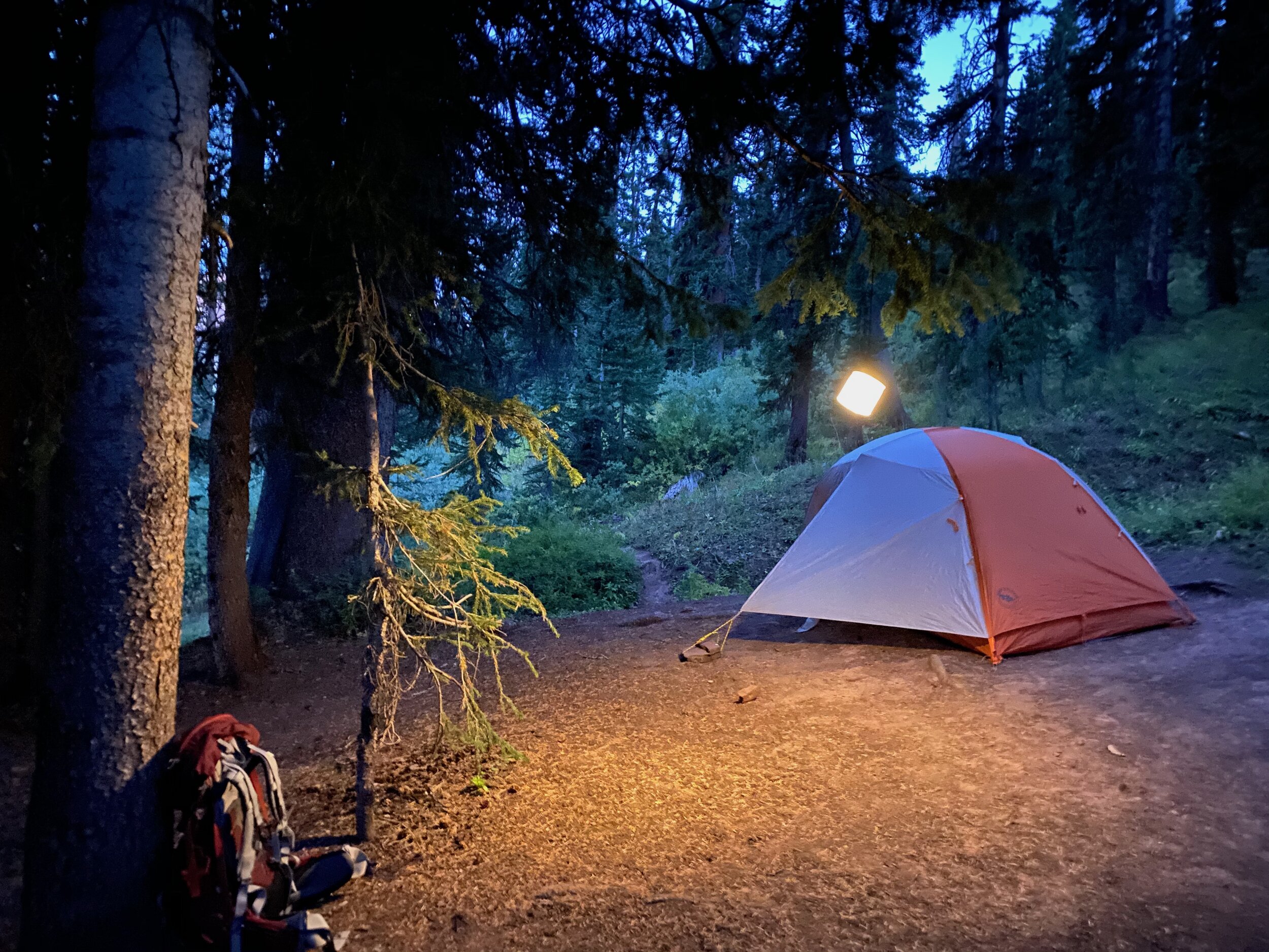
Campsite #1, approx. 75 yards up the hill from the lake

Snowmass Lake - End of day view

Sunset at the lake
Day #2: One pass down, three to go. The trek begins gaining elevation from Snowmass Lake as you head to Trail Rider Pass. Views are amazing as you look back and then forward to Trail Rider Pass at elevation of 12,415 feet. The descent has significant grade and without trekking poles, can be quite challenging. The trail is steep and slippery, as it is void of roots and larger rocks to slow the pace. As the trail levels out, you come to a sign around 2 miles from the pass that marks the North Fork Cutoff Trail. Take a left and continue the steep descent through an Aspen stand as you head to the a valley floor where you follow a river for a a number of miles before ascent #3 begins up to Frigid Air Pass. On the approach to the pass, we were sheltered from the wind, yet upon coming up and over…we quickly learned exactly where its name comes from. Windy. Like super windy - put on your rain / wind jacket NOW! If the wind doesn’t take your breath away, the view will get that job done. An expansive, 360 view is the reward you get to take in before making descent #3 on the way towards Maroon Pass.

Looking back at Snowmass Lake from the approach to Trail Rider Pass

Pano Shot from Frigid Air Pass
Where to camp on Night #2? Where’s the water
We knew we wanted to set camp somewhere between Frigid Air Pass and Maroon Pass, though the big debate was where. The biggest issue had to do with access to water. There are some really cool sites on along the trail, some close to water fall that looked fantastic. We decided however to press on closer to Maroon Pass based on intel from a few hikers we met coming from that direction who indicated there was a “watering hole” about a mile before the pass and a few nice campsites to choose from nearby. Getting there however required a rather steep series of switchbacks - the price to pay for a shorter climb the next morning, so we pressed on past the waterfall.
Here’s the deal. The “watering hole” is the last water access prior to Maroon Pass, so if you go past it, you either need to carry enough for the evening and next morning to get up and over the pass and down the valley before you replenish. The good news is that you literally can’t miss the “watering hole”. It sits about 50 yards off the trail and is easily visible. The challenge is that the only close by campsite is highly exposed (as in no shade), and if it is taken as in our case, you either need to back track about 1/2 mile to find a site (a few nice ones are there) OR…press on a half mile to snag one - and at that, the options aren’t great for the night (small sites or very uneven ground).

En route to Fravert Basin
Whichever you end up doing - check out the watering hole. Refill your water - jump in for a swim.
Campsite #2

The “Watering Hole” - Last source prior to Maroon Pass
Day #3
Every day of this trek yields different terrain and amazing views. We got up relatively early, having decided that instead of doing the trek in 4 days as most do, we set our sights on finishing this hike in 3 and then heading back towards Denver since I70 traffic is so unpredictable and I had to get to the airport by 1:30 to catch my flight home.
So it was an 11.5 mile day, but after getting to the top of Maroon Pass, the good news is the last 7 miles are basically all down hill!
Really enjoyed this day which included Maroon Pass, the easiest one to get over since the we had done much of the elevation gain the day prior; a few river crossings, including one spot we chilled for lunch and walked upstream a bit and soaked our feet in the river (cold…refreshing) and as a final extra bonus, spotted a moose in the lake right near the trailhead when we got out.
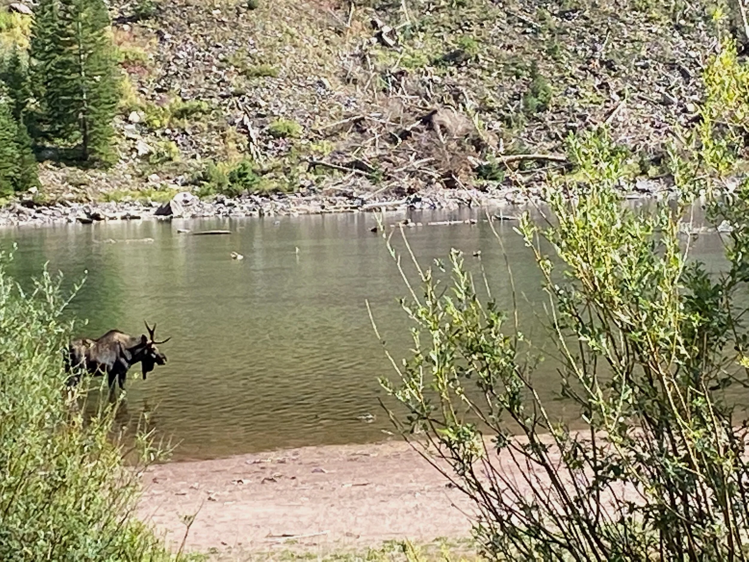
Spotted this guy as we exited the trail!